Overview
The AlphaAir 450 (AA450) from CHCNAV is very likely the best UAV LiDAR solution with integrated Livox Avia. The AlphaAir 450 is a major breakthrough in the democratization of mobile mapping technology, allowing its use by non-professional users in the geospatial reality capture industry and to those who have never been able to access such technology before. The AlphaAir 450 offers ease of use and high precision capabilities at an affordable price point.
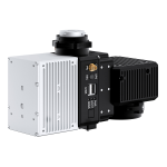
The AlphaAir 450 is the next generation of CHCNAV LiDAR system, which is widely used for power line inspection, topographic mapping, emergency response, agricultural and forestry surveys, and more. This all-in-one, lightweight and rugged system integrates a high-performance laser scanner with an industrial-grade professional 24 MP camera and a high-precision inertial navigation system for quality data collection.
The AlphaAir 450, with a Livox Avia scanner and an integrated high-resolution camera, is the latest UAV-based LiDAR system from CHCNAV. The LiDAR’s weight is a constraint for any UAV. The drone needs to lift the entire payload, as otherwise no data acquisition is possible! The lighter the unit, the greater the productivity as the UAV can fly longer.
The AlphaAir 450 combines industrial-grade GNSS and high-precision IMU. The high-accuracy INS is pivotal to collect high quality LiDAR data because without it, your point cloud would be nothing more than an arbitrary collection of points. This allows the AA450 to deliver an absolute accuracy of 5 to 10 cm. To further improve accuracy and precision, users can apply adjustment algorithms in the CoPre software.
AlphaAir 450 users can rely on a high level of protection (IP64) and extended operating temperature performance (down to -20°C and up to +50°C) in any field environment, as one never knows what the weather or site conditions will be like the day of the survey mission.
Thanks to the high-performance Livox Avia laser scanner, users will benefit from long-range scanning up to 450 m with a great points’ density on the measured surface. At a flying height of 100 m and a velocity of UAV 10 m/s, a single flight with a DJI M300 and the AlphaAir 450 can collect data covering about 2 km2 area with more than 200 pts/m2 density.
The AlphaAir 450 supports a variety of UAV platforms. With its integrated Skyport, it is fully compatible with a direct connection to the DJI M300. In addition, it can easily be installed on our CHCNAV BB4, VTOL and other multi-rotor UAVs with a shock absorbing mounting platform. Alternatively, the AlphaAir 450 can also be fitted to any third-party UAV that can carry its weight: multi-rotor or fixed-wing VTOL UAVs.
The AlphaAir 450 is a worldwide breakthrough in the democratization of 3D mobile mapping technology. It means that it addresses not only UAV LiDAR survey experts, but also users who had no access to this technology before, due to high investments and complicated workflow, which is not the case with the AA450.
Features
- Integrated DJI Skyport
- One touch to start
- Easy data transfer
- All-in-one software
Technical Specifications
| General | |
| Absolute Accuracy: | <10 cm HZ, <5 cm V |
| Accuracy Conditions: | Without control points, @50 m flight altitude AGL |
| Point Density on UAV Setup 5 m/s (18 km/h) Speed: | 570 pts/sqm @ 50 m AGL 280 pts/sqm @ 100 m AGL |
| Covered Area: | 2 km 2 area by 30 min UAV flight |
| Mounting: | Skyport for DJI M300, External power source with the dedicated port for other UAVs (CHCNAV Alphaport interface) |
| Physical | |
| Dimensions: | 13.6 cm × 12.8 cm × 7.7 cm 5.11 in × 4.72 in × 2.75 in |
| Weight: | 1 kg |
| Communications: | 1 × port for GNSS antenna Skyport interface 1× USB Type-C, copy speed up to 160 Mb/s |
| Data Storage: | 256 GB |
| Operation: | One-touch acquisition or remote control via DJI M300 Smart controller enterprise |
| Transport Box: | 1 × protected soft bag with custom precut foam |
| Laser Scanner | |
| Laser Class: | 1 (in accordance with IEC 60825-1:2014) |
| Max. Range, Reflectivity > 80%: | 450 m |
| Max. Range, Reflectivity > 10%: | 190 m |
| Max. Returns Supported: | Up to 3 |
| Accuracy: | 20 mm @ 20 m, 30 mm @100 m |
| Precision: | 15 mm |
| Field of View: | 70.4° (Horizontal) × 4.5° (Vertical) |
| Scan Rate: | 240 000 pts/sec (first or strongest return) 480 000 pts/sec (dual return) 720 000 pts/sec (triple return) |
| Imaging | |
| Camera Type: | Built-in calibrated Sony A5100 |
| Resolution: | 6000 × 4000 |
| Effective Pixels: | 24.3 MP, 11 fps |
| Positioning and Orientation | |
| GNSS System: | Multi-frequency GNSS GPS, GLONASS, BeiDou, Galileo, sampling frequency 5Hz |
| IMU Update Rate: | 600 Hz |
| Position accuracy NO GNSS outage: | 0.010 m RMS horizontal, 0.020 m RMS vertical, 0.01 degrees RMS pitch/roll, 0.04 degrees RMS heading |
| Environmental | |
| Operating Temperature: | -20°C to +50°C |
| Storage Temperature: | -20°C to +65°C |
| IP Rating: | IP64 |
| Operating Humidity: | 80%, non-condensing |
| Electrical | |
| Input Voltage: | DC 12 ~ 14 V |
| Power Consumption: | 32 W |
| Power Source: | Depending on UAV battery, or by Skyport from DJI M300 |
Video
Ordering
The AlphaAir 450 LiDAR payload from CHCNAV is available through Canal Geomatics. If you would like more information about this product, please feel free to get in touch with us by completing the Request Pricing form.